Scholarship of Teaching and Learning
Association of College and University Educators
After my five years in faculty leadership, I chose to refocus my energy on my teaching practice. Besides the professional development required to create OER material, along with improving my skill sets in geospatial technology, I signed up for ACUE Effective Teaching Practices through the Office of Faculty Development. The 25-module course concentrates on teaching practices effective in face-to-face and online instruction. Currently, the yearlong course is just over halfway through, so I have not completed the course at this time. However, the course has provided me opportunities to implement best teaching practices in real-time within my courses. Those include, but not limited to:
- Creating Opportunities to Motivate Students
- Active Learning Strategies
- Connecting with Students
- Engaging Underprepared Students
- Embracing Diversity in Your Classroom - Inclusive Course Syllabus
- Helping Students Persist in Your Classroom - College Readiness Activities
Equity, Diversity and Inclusion
- New Leadership Academy EDI Training (2022)
ACUE Online
Scholarship of Open Educational Resources
As noted before, most of my teaching and learning practice revolves around OER. In order to create and design OER textbooks, much research and professional development within the discipline must be addressed. Then requires a high level of scholarly writing to meet the standards of today’s more traditional textbooks. After the writing is complete, imagery and videos must be researched and analyzed for content accuracy along with following copyright laws. Once the textbook is designed, it must be edited many times. Usually by myself first, followed by an external review. Finally, the work needs to be peer-reviewed by credible reviewers to meet the academic rigor and quality expected in higher education. All of this requires me to focus on professional development in the content areas, in curriculum design and even teaching pedagogy. It also requires maintaining a scholarly network of professionals who can critically review and evaluate the accuracy and quality of the material.
Every year, for the past ten years, I have attended the international ESRI Users Conference in San Diego, California. Often, I have also presented during the Education Users Group that is part of the annual conference. The following are the presentations, to date, from a variety of disciplinary and educational conferences around the country.
Every year, for the past ten years, I have attended the international ESRI Users Conference in San Diego, California. Often, I have also presented during the Education Users Group that is part of the annual conference. The following are the presentations, to date, from a variety of disciplinary and educational conferences around the country.
Disciplinary Professional Development
GIS Training
- Nationally certified as a Geographic Information Systems Professional (GISP)
- Do-It-Yourself Geo Apps
- Going Places with Spacial Analysis
- Mapping and the Geospatial Revolution
- Cartography
- Earth Imagery at Work
- Certificate of completion on Cartography and Map Design, a certification recognized by URISA.
Geoinquiries Process at Salt Lake School District
|
Today’s students need to understand how the complex and dynamic human and natural systems interact in order to make smart decisions. National Geographic's Geo-Inquiry Processrelies on using a geographic perspective, offering a unique lens to analyze space, place, and the interconnections between both the human and natural world. Using both a geographic perspective and the Geo-Inquiry Process students begin to connect complex components, see patterns, and make connections that change their communities.
As the Utah Education Steward for the National Geographic, I have helped the Social Studies department at Salt Lake School District provide professional development training for secondary educators in the district achieve the Geo-Inquires credentials. |
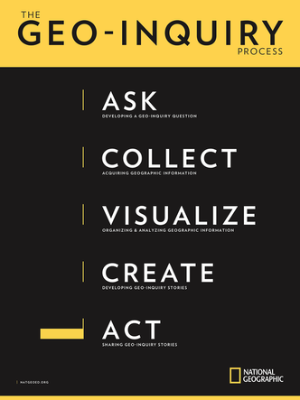
|
The National Geographic Geo-Inquiry Process asks educators to teach their students about five key principles to any geo-inquiry process:
- Ask: Develop a Geo-inquiry Question
- Collect: Acquire Geographic Information
- Visualize: Organize and Analyze Key Information and Data
- Create: Develop a Geo-Inquiries Story
- Act: Share the Geo-Inquiry Story with Others
Teaching with Mapping Technology
In partnership with the Office of Faculty Development and Learning Advancement, I taught two semester-long professional development workshops titled “Teaching with Mapping Technology during the 2017-2018 academic year. The course was taught in a hybrid modality, where most of the course was offered online, but bookend at the beginning and end with face-to-face instruction.
The goals of the professional development training was to demonstrate to SLCC faculty how they could implement free, web-based mapping technology into any of their courses. This could include any of the following:
The goals of the professional development training was to demonstrate to SLCC faculty how they could implement free, web-based mapping technology into any of their courses. This could include any of the following:
Presentations
Co-Presenter, Maricopa Community College, Phoenix, AZ, February 2021. Presentation: "Open at a College Near You."
Co-Presenter, Maricopa Community College, Phoenix, AZ, October 2020. Presentation: "Exploring the World of Open Education"
Co-Presenter, Maricopa Community College, Phoenix, AZ, September 2020. Presentation: "Exploring the World of Open Education"
Presenter, Distingished Geospatial Speaker Series, Directions Magazine, January 2020. Presentation: "Implementing Open Geography Education."
Presenter, Open Education Conference. Phoenix, AZ, October 2019. Presentation: "Open SLCC Initiative."
Presenter, Esri Education Summit, San Diego, CA, July 2018. Presentation: "Academic Pathways to Success."
Co-presenter, Esri Education Summit, San Diego, CA, July 2018. Presentation: "Ensuring Student Success in GIS Education and Beyond"
Co-presenter, High Tech Conference, Salt Lake City, UT, September 2017. Presentation: "The Role of Higher Education in Drone Technology"
Co-presenter, GeoEd 2017, Louisville, Kentucky, June 2017. Presentation: "What Geospatial Professionals Should Know"
Presenter, Utah Council for Land Surveyors Fall Summit, Salt Lake City, Utah, October 2015. Presentation: "Surveying and GIS"
Presenter, Open Education Conference, Vancouver, Canada, November 2015. Presentation: "OER Revolution in Geographic and Geospatial Technology Education"
Presenter, Esri Education Summit, San Diego, CA, July 2015. Presentation: "Remote Sensing Applications in Education."
Presenter, Esri Education Summit, San Diego, CA, July 2015. Presentation: "OER Revolution in the Geographic and Geospatial Technology Education."
Presenter, National Geospatial Technology Center for Excellence Webinar, May 2015. Presentation: "Integrating a Degree Qualifications Profile within a Geo-program"
Dastrup, R. A. (n.d.). How can a degree qualifications profile create a better geosciences workforce? Retrieved March 8, 2019, from https://www.directionsmag.com/article/1239
Co-presenter, AAEEBL-International Conference, Boston, MA, July 2012. Presentation: “Students Using ePortfolios to Document Learning Abroad in England and Japan”
Co-presenter, Intermountain Region Sustainability Summit, Odgen, UT, February 2012. Presentation: "Sustainability and Higher Education in Utah"
Co-presenter, SLCC Board of Trustees, Salt Lake City, UT, December 2012. Presentation: "Sustainability at SLCC"
Presenter, National GeoTech Center Webinar Series, December 2011. Presentation: "ePortfolios in GIS Programs" URL: YouTube
Presenter, AAEEBL-International Conference, Boston, MA, July 2011. Presentation: "Empowering Students through Active Interdisciplinary Learning"
Presenter, Utah Geographic Information Council Annual Conference, Logan, UT, April 2011. Pesentation: "GIS Educator Workshop"
Presenter, Utah Coalition for Education Technology, Salt Lake City, UT, April 2011. Presentation: "Geospatial Technology in the Classroom"
Presented, Salt Lake School District Teacher Workshop, Salt Lake City, UT, February 2011. Presented: "Geospatial Technology in the Classroom"
Presenter, Utth Geographic Council Annual Conference, Ogden, UT, November 2010. Presentation: " Integrating Mapping in the Classroom"
Presenter, National Council for Geographic Education Annual Conference, Savannah, Georgia, September 2010. Presentation: "Integrating Remote Sensing with Community College Curriculum"
Presenter, Esri Education Conference, San Diego, CA, July 2010. Presentation: "Integrating Remote Sensing with Community College Curriculum"
Presenter, Utah Geographic Information Council, Moab, UT, March 2010. Presentation: "GIS Education
Workshop"
Presenter, National Council for Geographic Education Annual Conference, San Juan, Puerto Rico, September 2009. Presentation: "Using MODIS to Study the Darfur Conflict"
Distinguished Faculty Lecture
Professional Conferences
Educause Conference (2021)
Esri International Users Conference (2009-Present)
National GeoTech Center of Excellence, GeoEd Conference (2015-Present)
National GeoTech Center of Excellence GIS Day (2020-Present)
What is an Educated Person? Conference (2016-2018)
Esri International Users Conference (2009-Present)
National GeoTech Center of Excellence, GeoEd Conference (2015-Present)
National GeoTech Center of Excellence GIS Day (2020-Present)
What is an Educated Person? Conference (2016-2018)
Professional Memberships
Assistant Director of the National Geospatial Technology Center for Excellence
Active member of the Association of American Geographers (AAG).
Active member of National Council for Geographic Education (NCGE).
Active member of the national GIS organization URISA.
Active member of the Utah Geographic Information Council (UGIC).
Active member of the Salt Lake GIS Users Group (SLUG).
- Web developer for the National GeoTech Center for Excellence.
- Developing Creative Commons licensed model courses on geospatial technology for the National GeoTech Center for Excellence.
- Developing a white-paper on underserved and underrepresented populations in geospatial technology programs within community colleges.
Active member of the Association of American Geographers (AAG).
Active member of National Council for Geographic Education (NCGE).
Active member of the national GIS organization URISA.
Active member of the Utah Geographic Information Council (UGIC).
Active member of the Salt Lake GIS Users Group (SLUG).
Grants and Awards
Open Geography Award for Excellence, Open Education Consortium, 2019-2020
Co-Recipient, SLCC Innovation of the Year, 2013-2014
Utah Green Business Award: Recycling Program at SLCC, November 2011
Co-Grantee, Department of Labor $20 million TAACCCT grant, October 2011-2016
Utah System of Higher Education Exemplary Use of Technology Award, May 23, 2008
Participant, NSF Funded iGETT Program, July 2007-2009
- Open Education Consortium Website
- The Fountain - The Official SLCC Blog
- National GeoTech Center Quarterly Newsletter
- Directions Magazine Distinguished Geospatial Speakers Series: Implementing Open Geography Educaiton
Co-Recipient, SLCC Innovation of the Year, 2013-2014
Utah Green Business Award: Recycling Program at SLCC, November 2011
Co-Grantee, Department of Labor $20 million TAACCCT grant, October 2011-2016
Utah System of Higher Education Exemplary Use of Technology Award, May 23, 2008
Participant, NSF Funded iGETT Program, July 2007-2009
